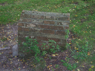
This village pump and its shelter, (pictures below) were built to mark Queen Victoria's Golden Jubilee at the junction of New Pond Road (roughly from the NNE) and The Street (runs roughly WSW-ESE) which is the main route through the village. I will provide grid references when I have access to my 1:25,000 map again.
There is no evidence of an earlier structure on the site, and I will earmark this for further research. The well is adjacent to an old toll house that marked the beginning of a turnpike. This was demolished in 1876. There is nothing at the site to suggest that there was an earlier well here and it is possible that the shaft was bored especially for the jubilee, to portray the monarch as benevolent provider of drinking water, perhaps, or to demonstrate the largesse of the Parish and its leading members, along with the village's love of the Queen-Empress. See: http://www.benendenvillage.org.uk/notes.htm for a little more detail.
As can be seen, the pump mechanism has been removed from this well, probably for recycling into military hardware in World War Two, like many of its kind. This also needs verification.
There is a similar well, built in 1897 to commemorate the Diamond Jubilee, in the village of Iden Green, to the SW of Benenden. The 1:50k OS map shows that there was a Roman ford (NGR to follow), and surely therefore a road, between the two present-day settlements. Neither of these wells are marked on the 1:50k map.
The Benenden Well is near an ornamental lake called New Pond and a moated manor house, the former of which belonged to the latter. Both of these are at the southern extremity of the Hemsted Estate, now the site of Benenden School, where a great house has been situated since at least 1377. I will look into the relationship between these buildings.
just3days, the NWI Videographer reports a similar 1887 well in Staffordshire, in a posting to the NWI forum (http://nwi.skyphos.co.uk/phpbb/viewtopic.php?t=172) made on September 5th 2007. Tim says:
' Tip off from a librarian at Barton Under Needwood yielded a well called the Queen's Well at Dunstall, for Victoria's Jubilee in 1887. Nothing on any databases - but anything about this well being here earlier, or any holy attributes? SK 1820 2078 ' (Tim Prevett, NWI Index, Sept. 2007).
I will visit Iden Green as soon as I am able, and will research both wells. For now, here are some shots of the Queen's Well at Benenden:
All the latest news from the Archivist of the National Wells Index
Visit the NWI Website and Forum Index
http://nwi.skyphos.co.uk/
http://nwi.skyphos.co.uk/phpbb/index.php
Join and Participate!
http://nwi.skyphos.co.uk/
http://nwi.skyphos.co.uk/phpbb/index.php
Join and Participate!
Wednesday, 5 September 2007
Tuesday, 4 September 2007
A curious structure over a spring at Benenden School, nr Cranbrook, Kent.
The structure in the following pictures is located at Benenden School, nr Cranbrook Kent, on the former Hemsted estate which was a gentleman's country seat since at least 1377. It is marked as a spring on the 1:25,000 OS map (sheet no and gr to follow). The watercourse leading down the hill to the south is plainly apparent, though there is no water at present. However, the ground is moist and mossy (sphagnum) in the whole area surrounding the spring, which is covered by a grove of silver birch and other trees. The ground on which the spring stands is highly disturbed - very uneven, with some hint of a raised circular platform, through which the now dry water course cuts its way to the south. I will post some more precise measurements as soon as I am able, but the full size of the disturbed ground and grove of trees is no more than 50m radius, probably nearer 30m.
As can be seen, the structure once had a wooden door, parts of which are lying on the ground outside, with some buried in the mud floor of the interior.
The site is located on a ridge, the 'High Weald', that is a watershed, with springs running off to both north and south. Further down, near Benenden Village there is a water culvert some centuries old over a stream, that still carries a flow. This is related to ancient iron mining in the area. There are also many clay pits in the vicinity, now filled with water, from which the raw materials for brinks have been extracted at least since the sixteenth century.
To give some idea of scale, the person standing next to the brick structure over the spring is 5'3 " tall. The bricks are machine cut and resemble Victorian house bricks. The shape is reminiscent of an early medieval oratory, such as that at Galarus, Co. Kerry. Situated in a grove of established silver birch trees, with one mature oak and one elderly and dying Spanish Chestnut, the structure over the spring has the look of some kind of folly or purpose-built curio. There is no sign of Victorian water pipes, of the iron variety often used to carry water from springs. The water supply to Benenden Village was provided, before mains water, by the Queen's Well, in any case, at the west end of the village high street (insert ngr).
An inscription in cement on the north side of the spring structure says that is was restored in 1971, long after Benenden School purchased the Hemsted Estate in 1923. This effort was probably some enterprise by the school. As I have a close contact at the school I hope to have access to the library soon, and will also look elsewhere for further information on this enigmatic and interesting structure. The school itself is an independent boarding school for girls aged 11-18, with a 240 acre campus and many modern buildings grouped around the sixteenth century Hemsted House. The grounds are beautifully kept with a recent restoration of several water features.
When I saw this structure from a distance I thought that it might be a C18th Ice House, but the distance from the great house, nearly 10 minutes' walk unloaded and the small size than no human could, enter, and lack of any other structural evidence, along with the fact that the OS map marks a spring here, and a water course is plainly visible all mitigate against this. There is no sign of a spring anywhere else nearby, though there is some mud and water on the surface, despite current dry weather, in the area under the trees.
Subscribe to:
Posts (Atom)